Introduction
Since the second half of 2025, social conflict has emerged in South Korea over issues related to high-rise development under the Sewoon District redevelopment plan and the potential impairment of Jongmyo’s value as cultural heritage. The Seoul Metropolitan Government maintains that the Sewoon District is eligible for development under current Seoul regulations because, based on Jongmyo Jeongjeon, it lies outside the 100 m boundary of the Historic and Cultural Environment Preservation Area (Kim & Kim, 2025). In response, the Korea Heritage Service has argued that height controls are necessary to safeguard the visual integrity of the area surrounding Jongmyo and has requested that the appropriateness of development be verified through a heritage impact assessment (Korea Heritage Service, 2026). In addition, some civic organizations have argued that the validity and publicness of building-height relaxation and increased design costs in the redevelopment of Sewoon District 4 have not been sufficiently verified, and have requested that the Seoul Metropolitan Government and SH Corporation disclose relevant meeting records and additional materials (NBN TV, 2026).
The current Seoul Landscape Master Plan identifies major natural and urban landscape resources, such as Namsan, the Inner Four Mountains, and the Han River waterfront, as detailed subjects of landscape management (Seoul Metropolitan Government, 2016). However, it has not yet led to the establishment of specific and applicable management standards for modern public pedestrian landscapes such as Cheonggyecheon. This indicates that Seoul’s existing landscape management system has been operated primarily around historically recognized landscape resources.
By contrast, major cities overseas not only recognize public pedestrian spaces and view corridors themselves as important visual assets, but also operate form-based management systems that take pedestrian landscapes into account. First, Singapore’s Singapore River Planning Area designates the riverfront promenades along both sides of the Singapore River as key spaces for public access and use, and requires development sites to be set back from the river wall to secure an approximately 15 m-wide promenade. In addition, by assigning relatively low building heights to riverfront areas where the pedestrian scale needs to be maintained, while allowing relatively higher development in rear areas that do not directly face the river, Singapore manages the waterfront pedestrian environment and urban skyline in an integrated manner (Urban Redevelopment Authority, 2025).
Second, the City of Chicago, through the Chicago River Design Guidelines, requires a minimum setback of 30 feet from the river for riverfront development and manages this space as publicly accessible open space and a continuous multi-use path. The guidelines also encourage riverfront buildings and vehicular areas to be located outside the river setback, ensuring that development is planned not to turn its back on the river, but to activate the riverfront and enhance public accessibility (City of Chicago, 2019). In this way, overseas cities already regard the landscapes of linear public spaces, such as public pedestrian corridors experienced in everyday life, as important subjects of urban management. They also manage diverse aspects of urban form, including building placement, pedestrian access, open space, and waterfront landscapes, in a three-dimensional and integrated manner. These international cases demonstrate that public pedestrian spaces can also serve as important subjects of landscape management.
Cheonggyecheon is a representative public pedestrian space and symbolic linear landscape corridor that connects downtown Seoul from east to west. It is also a major public space used daily by citizens and tourists, and is already recognized as a representative urban asset of Seoul. According to the broad concept of heritage advanced by David Harvey and Laurajane Smith, Cheonggyecheon can be understood not merely as a physical object of preservation, but as a contemporary urban heritage in which historical memory, social experience, and present-day interpretation and contestation are layered together (Harvey, 2001; Smith, 2006). Furthermore, because landscape value is not fixed but is continuously transformed and re-evaluated through citizens’ perceptions and socio-cultural contexts (Hwang, 2011), it is necessary to examine landscape changes around Cheonggyecheon before redevelopment in the Sewoon District proceeds in earnest, and to establish a landscape management system that reflects these changes (Fig. 1).
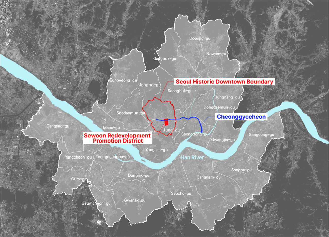
According to recently announced redevelopment directions for the Sewoon Redevelopment Promotion District, high-density, mixed-use development is planned in some areas, with maximum heights relaxed to approximately 200 m. Accordingly, substantial changes are expected in the urban landscape around Cheonggyecheon, which has historically been characterized by an industrial landscape of low- and mid-rise buildings (Newsis, 2025). Moreover, the high-rise and large-scale redevelopment of buildings around Cheonggyecheon is not merely a physical transformation of the urban landscape. As Cheonggyecheon forms a continuous pedestrian landscape, a reduction in Visual Openness caused by redevelopment may translate into visual burden perceived by pedestrians. Such visual burden may also be closely associated with negative evaluations of the pedestrian environment.
This study aims to empirically compare and analyze changes in the pedestrian landscape of Cheonggyecheon before and after redevelopment in the Sewoon District. Whereas urban landscape studies and redevelopment assessments have often relied on bird’s-eye views or qualitative discussion, this study conducts a quantitative analysis of the visual environment from the actual pedestrian viewpoint. To this end, Sky Exposure and Visual Obstruction are established as indicators for identifying Visual Openness from the perspective of Cheonggyecheon pedestrians, and the study analyzes how these indicators change before and after redevelopment in the Sewoon District.
Study area
The 2040 Seoul Comprehensive Plan positions downtown Seoul as a center of international cultural exchange grounded in historical and cultural assets, and proposes a planning direction that simultaneously strengthens downtown competitiveness and improves green and pedestrian environments. In particular, Cheonggyecheon is treated as a core east-west axis of downtown Seoul, connecting the commercial and business functions of the Jongno and Euljiro areas with the north-south green axis. To this end, the plan establishes a basic principle for downtown renewal in which height and floor-area-ratio standards are applied flexibly, while corresponding public contributions and green spaces are secured. This plan functions as the highest-level plan that determines the planning direction of downtown Seoul (Seoul Metropolitan Government, 2023a).
More specifically, the 2023 Downtown Seoul Master Plan designates the Cheonggyecheon-Jongno-Euljiro area as a global commercial axis and treats the Sewoon District as a new-industry hub and a key node for establishing the north-south green axis. Accordingly, the redevelopment direction for the Sewoon District is presented not simply as the redevelopment of an aging area, but as a strategy to strengthen downtown functions through high-density, mixed-use development while simultaneously securing pedestrian space, green space, and public space. In particular, the plan moves beyond uniform maximum-height controls and applies reference heights by district. It also expands the possibility of high-rise development premised on securing publicness by allowing height relaxation through incentive plans that reflect the characteristics of each district (Seoul Metropolitan Government, 2023b).
In addition, under the Green Ecological Downtown Policy and the Standards for the Creation, Operation, and Management of Open Green Spaces in a Seoul Metropolitan Government (2025), Seoul proposes flexible height-management criteria based on “Open green space creation-height relaxation” moving away from simple density control. This system identifies the creation of open green spaces as a core element of securing publicness, and allows floor-area-ratio and height relaxation when open green spaces linked to public open spaces and pedestrian-green corridors are secured. It can be understood as an institutional basis that enables more flexible high-density, mixed-use development on the condition that public green spaces and pedestrian spaces are provided, departing from the conventional emphasis on uniform maximum-height controls. In particular, the areas around Cheonggyecheon and the north-south green axis are treated as key spaces for realizing the Green Ecological Downtown, and the linkage between open green spaces and the public pedestrian system is regarded as an important consideration (Seoul Metropolitan Government, 2025).
This direction is reflected as a concrete urban redevelopment strategy in the 2030 Master Plan for Urban and Residential Environment Renewal (Amended). The plan presents the creation of “A pleasant green city where greenery and buildings coexist” through the provision of green spaces in downtown Seoul as a major goal, and explicitly identifies the need to shift toward an open-green-space-centered renewal system and to improve standards for floor-area-ratio and height relaxation. It also designates areas around the north-south green axis, including the Sewoon District, as key nodes for downtown revitalization and new-industry development, and reflects redevelopment potential throughout the downtown area by expanding planned renewal zones and mixed-use potential areas to the Euljiro, Chungmuro, Gwansu-dong, Jugyo-dong, and Ojang-dong areas. Accordingly, downtown redevelopment around the Sewoon District can be understood not as development at the scale of individual blocks, but as part of a broader strategy for restructuring the downtown area around Cheonggyecheon and the north-south green axis (Seoul Metropolitan Government, 2026).
On this basis, the Sewoon District area has been designated and managed as a Redevelopment Promotion District under the Redevelopment Promotion Plan. Recent amendments to the Redevelopment Promotion Plan propose appropriate locations for parks and open green spaces by promotion zone in accordance with higher-level plans, and large-scale development substantially exceeding the standard floor-area ratio has been planned in some promotion zones (Seoul Metropolitan Government, 2024). However, these plans focus primarily on the positive effects of development, such as securing green space, public contributions, and economic revitalization, and do not specifically address the landscape impacts of future high-rise and high-density development on urban-space users, including high-rise development resulting from height relaxation and parcel enlargement resulting from the absence of limits on maximum development scale.
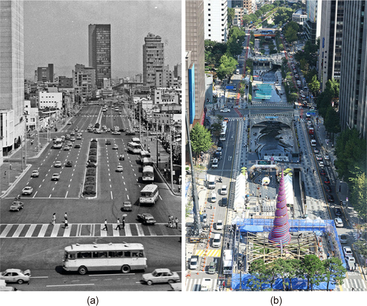
Cheonggyecheon is an urban stream that was artificially improved through the Gaecheon (stream excavation) project in the early Joseon Dynasty. It flows eastward through central Seoul, collecting runoff from within the Four Great Gates, before joining the Jungnang Stream and eventually the Han River, with a total length of approximately 13.7 km. Since the Joseon Dynasty, Cheonggyecheon has played a significant role in flood control and the formation of Seoul's urban spatial structure. However, following Korea's liberation in 1945, shantytowns developed along the stream, while the discharge of domestic sewage severely degraded water quality. As a result, the area came to be recognized as a representative slum reflecting the poor urban conditions of postwar Seoul. To address these problems, the Seoul Metropolitan Government implemented the covering and road construction of Cheonggyecheon as an urban renewal strategy aimed at improving sanitation while alleviating traffic congestion in the city center (Cheonggyecheon Museum, 2013; Son, 2003). When traffic congestion was not substantially alleviated even after the stream was covered, an elevated highway was constructed above Cheonggyecheon. Following its construction, rapid urbanization and motorization substantially increased traffic demand in Seoul. By the early 2000s, however, structural deterioration had raised safety concerns, while growing public demand for restoring the historical and cultural value of the downtown area prompted the Seoul Metropolitan Government to remove the elevated highway and restore Cheonggyecheon. The city divided the 5.8 km restoration section from Taepyeong-ro in Jung-gu through Dongdaemun to Sindap Railway Bridge in Seongdong-gu into three segments: a 2 km section from the starting point to Gwangjang Market with history and tradition as its central theme; a 2.1 km section from Cheonggye Plaza to Nangye-ro centered on culture and modernity; and a 1.7 km section to Sindap Railway Bridge conceived along a temporal axis of nature and the future (Cho, 2005; Seoul Metropolitan Government, 2006; Son, 2003). Since restoration, Cheonggyecheon has recorded more than 330 million cumulative visitors over approximately 20 years, demonstrating a high level of use. It also serves as a cultural hub in the downtown area, hosting various cultural events such as citizen-participatory programs, nighttime light festivals, exhibitions, and performances (Moon, 2025).
In this way, Cheonggyecheon is not merely an urban waterfront space but a representative linear public pedestrian corridor that connects the historical and cultural flows of downtown Seoul. The linearity inherent in a watercourse distinguishes it from point-based public spaces such as plazas or parks, because users experience the city through a continuous flow of landscape rather than from a single point. For this reason, the pedestrian landscape of Cheonggyecheon needs to be analyzed not as a set of individual viewpoints, but within the flow of visual experience formed through sequential movement (Fig. 2).
Methods
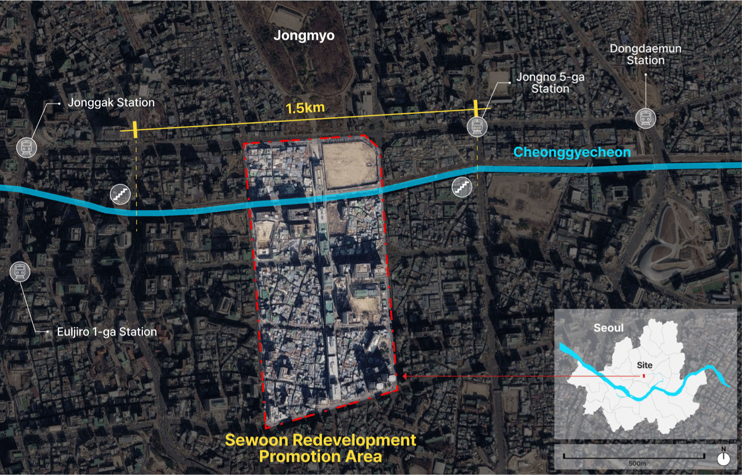
The study site is the Sewoon Redevelopment Promotion District, one of the representative and large-scale redevelopment areas in downtown Seoul, covering approximately 43.9 ha. A Redevelopment Promotion District is a district designated under a redevelopment promotion plan pursuant to the Special Act on the Promotion of Urban Renewal in order to systematically renew an entire urban area. The Sewoon Redevelopment Promotion District is currently undergoing large-scale development through relatively high floor-area ratios and height relaxation within downtown Seoul. Because Cheonggyecheon crosses the center of the district in an east-west direction, the site is suitable for directly analyzing changes in the pedestrian landscape along Cheonggyecheon before and after redevelopment.
The spatial scope of the analysis was expanded to include not only the section subject to direct landscape change from Sewoon District redevelopment, but also areas expected to be affected in terms of the pedestrian landscape. The impact on the pedestrian landscape was expected to be concentrated in the section directly adjacent to the Sewoon District, while also potentially extending for a certain distance beyond the adjacent section. Therefore, this study defined the approximately 500 m frontage of the Sewoon District along Cheonggyecheon as the direct impact zone, and additionally included 500 m outer sections on both sides to examine whether the magnitude of landscape change attenuates and converges beyond the direct impact zone. This enabled a continuous analytical framework for comparing from where, and to what extent, landscape changes occur before and after redevelopment.
In addition, both endpoints of the analysis section were selected to correspond to physical nodes through which pedestrians can enter and exit the Cheonggyecheon waterfront pedestrian path. Because Cheonggyecheon is located at a lower level than the surrounding roads, vertical movement through stair-type entrances near bridges is required to access the waterfront pedestrian path from street level. The western endpoint is linked to Jonggak Station (Line 1) and Euljiro 1-ga Station (Line 2), and functions as a node that allows access to the waterfront pedestrian path through stair-type entrances near bridges. The eastern endpoint is adjacent to Jongno 5-ga Station (Line 1) and Dongdaemun Station (Lines 1 and 4), and likewise functions as a major node in the eastern direction through which pedestrians can enter the waterfront path via stair-type entrances near bridges. Thus, the two endpoints of the section are justified as points where the spatial extent of redevelopment-induced landscape impacts intersects with actual pedestrian movement routes (Fig. 3).
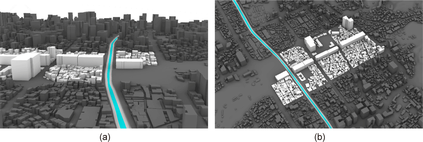
To compare the effects of redevelopment in the Sewoon Redevelopment Promotion District on the Cheonggyecheon pedestrian environment, two urban-form scenarios were constructed: pre- and post-redevelopment. The pre-redevelopment data for the Sewoon Promotion District were constructed based on the latest Seoul digital topographic maps and aerial imagery provided by the Ministry of Land, Infrastructure and Transport. Using QGIS, parcel boundaries, road geometries, and building information within the analysis area were edited from the digital topographic map, and the placement and form of buildings with missing information were verified using aerial imagery. Based on this, a 2D drawing was prepared for a 500 m radius around the study site and converted into a three-dimensional model in Rhino 3D.
The post-redevelopment data were constructed only for the Sewoon Redevelopment Promotion District, based on the amendment decision for the Sewoon Redevelopment Promotion District announced by the Seoul Metropolitan Government (No. 2024-316) and the published project implementation authorization materials for individual promotion zones. First, parcels were delineated by reflecting the boundaries of the Redevelopment Promotion District shown in the land-use plan of the amendment decision, and the recommended locations of open green spaces and parks were incorporated. For zones where project implementation authorizations and architectural plans had been disclosed, the placement, scale, and form of buildings were modeled as closely as possible based on bird’s-eye views and development-plan materials.
For zones where specific architectural plans had not been disclosed, simulation-based development standards were established with reference to the development direction presented in Seoul’s Redevelopment Promotion Plan and nearby project implementation authorization cases. First, the building coverage ratio was applied differentially according to parcel size. A ratio of approximately 40% was applied to parcels of 3,000 m2 or more, and approximately 50% to parcels under 3,000 m2, reflecting the characteristics of recent downtown redevelopment projects premised on securing open green spaces. The floor-area ratio was also applied differentially according to parcel size. A floor-area ratio of 1,500% was applied to parcels of 10,000 m2 or more, and 1,300% to parcels of 7,000–10,000 m2; for smaller parcels, approximately 1.2 times the permitted floor-area ratio under the Redevelopment Promotion Plan was applied. These values were set with reference to the actual planned floor-area ratios of recently authorized integrated development cases within the Sewoon District. Building height was calculated using an average floor height of 4.5 m, considering the characteristics of office- and commercial-oriented downtown development. Final heights were derived from the applied floor-area and building coverage ratios, and were capped at 203 m or less in consideration of the height levels shown in Seoul’s Redevelopment Promotion Plan and recent development cases.
The two scenarios were constructed by keeping the Cheonggyecheon pedestrian path and surrounding urban fabric identical while substituting the urban form of the Sewoon Redevelopment Promotion District before and after redevelopment. The purpose of this scenario construction was not to precisely reproduce the actual design of each individual project, but to isolate the effects of urban-form change caused by redevelopment and to compare and evaluate the potential impacts of future high-density, high-rise development in the Sewoon District on the Cheonggyecheon pedestrian landscape (Figs. 4 and 5).
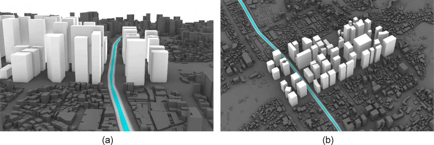
It should also be noted that the post-redevelopment model is an academic simulation model constructed from approximate location, massing, and height information derived from publicly available data, planning documents, and reference images. Therefore, the model is not intended to represent an official, legally binding, or fully verified redevelopment plan, and any discrepancies between the simulated model and actual or future development conditions should not be interpreted as legal responsibility on the part of the authors.
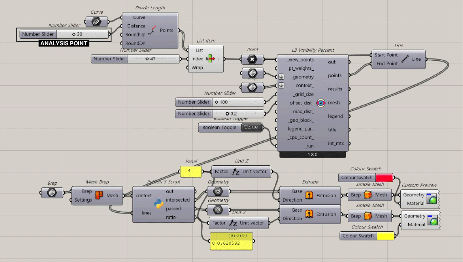
Using the LB Human to Sky Relation component of Ladybug Tools on the Grasshopper platform, this study conducted a Sky Exposure Analysis based on the Effective View Angle. The Effective View Angle is defined as the proportion of a pedestrian’s omnidirectional (360-degree) field of view in which the sky is visible without being blocked by buildings. The LB Human to Sky Relation component calculates the visual relationship between surrounding obstacles and the sky based on pedestrian eye level, thereby quantifying the degree to which the sky is exposed from the pedestrian viewpoint. To explain this analytical principle and its results intuitively, this study visualizes the viewing relationship extending from pedestrian eye level toward the sky in the form of rays. The proportion of the view that is not blocked by buildings and remains open to the sky is calculated as Sky Exposure. The resulting Sky Exposure value represents the ratio of the field of view that opens toward the sky without being obstructed by surrounding buildings; lower values indicate more severe sky obstruction by buildings. This analysis is used to quantitatively evaluate the Visual Openness perceived by pedestrians in actual space.
According to studies analyzing the relationship between the urban visual environment and psychological perception, openness expressed as the proportion of sky in an image is closely related to the aesthetic value of the landscape and has been reported to have a negative correlation with depression and boredom (Wedyan & Saeidi-Rizi, 2024). In this study, the same analytical conditions were applied to each observation point generated at regular intervals along the Cheonggyecheon pedestrian path, and Sky Exposure was calculated for both pre- and post-redevelopment scenarios. The resulting values were used as a quantitative indicator for evaluating pedestrians’ Visual Openness.
The Reconize component developed in this study is an analytical method for quantifying Visual Obstruction caused by surrounding buildings at the eye level of an actual pedestrian. Conventional Isovist analysis is limited to representing the field of view on a horizontal plane as a two-dimensional polygon from a specific observation point, and has a structural limitation in that it does not consider the vertical dimension (Morello & Ratti, 2009, p. 838). To address this limitation, analytical methods that extend the visible area into three dimensions have been proposed, and custom analytical tools implemented through ray casting in Rhino and Grasshopper have also been developed within this line of research (Koltsova et al., 2013).
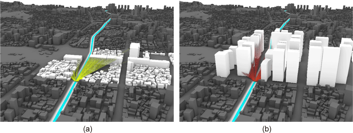
The Reconize component is based on this 3D ray-casting method, but is distinguished by its design, which separately calculates the number of obstructed rays caused by the Analysis Building and by Other Buildings. To do so, the intersection distances for the target building and surrounding obstacles (tTarget and tObs) are calculated simultaneously, and a distance-comparison logic (tTarget<tObs) is used to physically determine whether a line of sight reaches the target building precisely or is first blocked by surrounding buildings. This makes it possible to independently quantify only the impact of the Sewoon District redevelopment building masses on the view of Cheonggyecheon pedestrians, thereby enabling a clearer separation and comparison of the causes of landscape change before and after redevelopment.
In terms of the algorithm, the horizontal angle is first subdivided, and a unique Local Right Vector is derived through the cross product between each sight vector and the Z-axis. The vertical angle is then rotated around this vector, adopting a spherical-coordinate subdivision method that uniformly divides the hemispherical field of view without distortion. This resolves the distortion and clustering of sight vectors that can occur when rotation is performed with respect to the global axis, thereby improving analytical accuracy. In addition, the bounding box of the analysis building mesh is used as a primary filter to exclude in advance rays with no possibility of intersection, maximizing computational speed in large-scale urban analyses involving thousands of rays.
The inputs include the Analysis Point, Analysis Building, Other Buildings, centerPT of site, and horizontal and vertical analysis angles and intervals. The outputs classify the emitted sight vectors (rays), rays colliding with the analysis building (analyBuildingHits), and rays colliding with surrounding buildings (otherBuildingHits) into three categories: success, failure, and open sky. This enables the independent quantification of the impacts of redevelopment target buildings and surrounding buildings on the view at a specific pedestrian point.
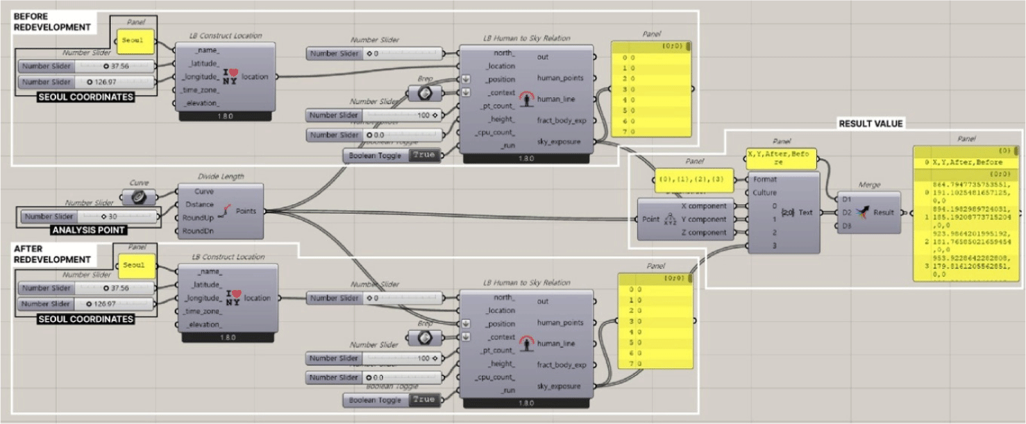
For the Sky Exposure Analysis, 50 observation points were evenly placed at 30 m intervals along the Cheonggyecheon pedestrian axis, and a curve-division method was applied to the point setup so that continuous spatial sampling could be performed along the pedestrian route. Seoul’s latitude (37.56°N) and longitude (126.97°E) were entered into the LB Construct Location component to set the coordinates of the analysis location, and identical analytical conditions were applied independently to the pre- and post-redevelopment scenarios. At each observation point, the LB Human to Sky Relation component recognizes building geometry (Brep) as an obstacle, calculates the degree to which emitted rays are blocked by building surfaces, and outputs the unobstructed sky exposure ratio as a value between 0 and 1.
The final results are output as the coordinates (X, Y) of each observation point and the Sky Exposure values before and after redevelopment; based on these values, sectional change patterns were visualized and quantitatively compared (Figs. 6 and 7).
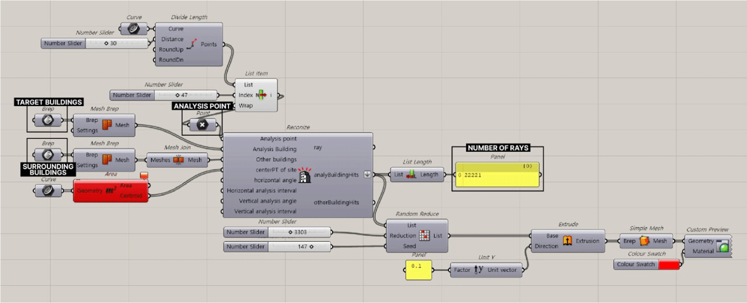
Next, to evaluate changes in pedestrians’ actual visual perception, a Visual Obstruction analysis was conducted. The observation points were placed at 30 m intervals along the Cheonggyecheon pedestrian axis to reflect pedestrians’ actual movement experience. Multiple sight rays were emitted in the horizontal and vertical directions from each observation point to calculate the field of view obstructed by surrounding buildings; higher values indicate that the pedestrian’s view is more extensively blocked by surrounding buildings. The input values consist of three elements: the Analysis Point, Analysis Building, and Other Buildings. The target and surrounding buildings were each converted from Brep geometry into meshes for input. The area and centroid of each building were then used as analytical reference values. The ray-emission setting was configured to emit a total of 9,003 rays from each observation point (Number Slider=9,003), and the seed value was fixed (Seed=147) to ensure reproducibility. Among the emitted rays, the rays obstructed by the target building (AnalyBuildingHits) and those obstructed by surrounding buildings (otherBuilding Hits) were separately calculated, and the number of obstructed rays was quantified as the list length of the sampled list using Random Reduce. The resulting values were output through a Panel, and this study used the number of rays obstructed by the target building (analyBuildingHits) as the primary analytical indicator (Fig. 8).
The two analyses form a complementary relationship by capturing the pedestrian visual environment from different dimensions. Sky Exposure Analysis calculates the proportion of the sky within the hemispherical view above the pedestrian’s head and reflects the degree of vertical obstruction caused by surrounding buildings. By contrast, Visual Obstruction represents the extent to which the pedestrian’s omnidirectional view is physically blocked by calculating the cumulative number of sight rays emitted horizontally and vertically that are obstructed by building surfaces. In other words, whereas Sky Exposure measures “how open the view is when looking upward,” Visual Obstruction measures “how blocked the view is when looking around.” Although the two indicators quantify distinct visual dimensions, only when used together can they constitute a comprehensive picture of the spatial openness perceived by pedestrians.
Results
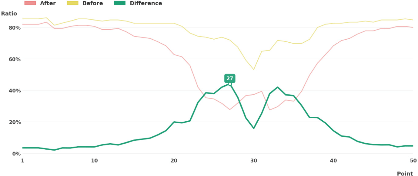
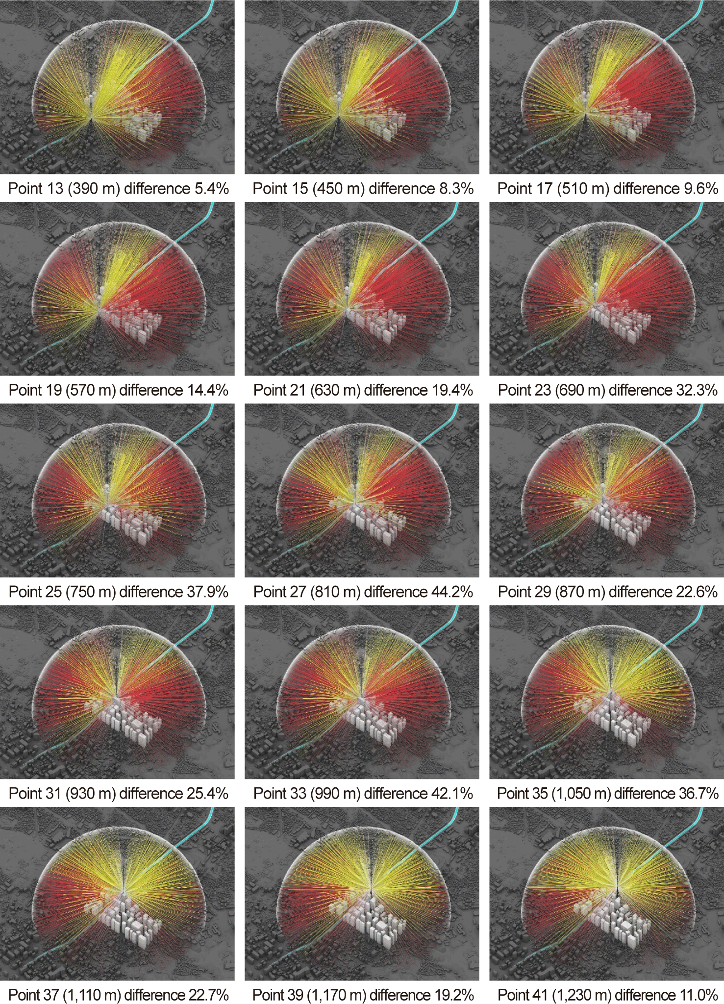
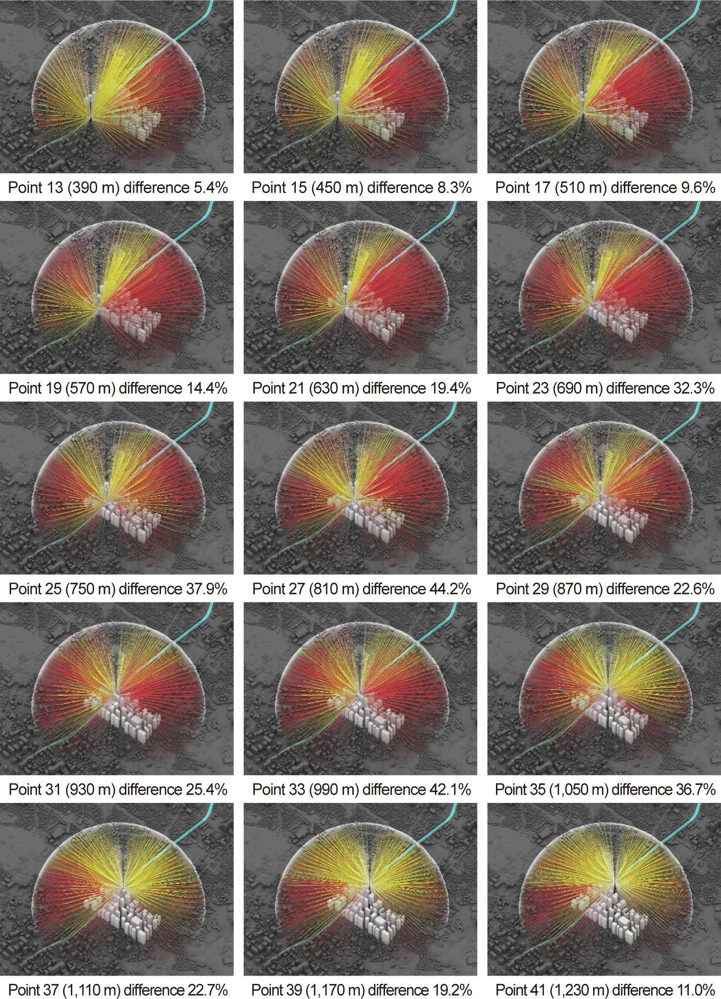
The comparative analysis of the pre- and post-redevelopment scenarios for the Sewoon District showed that the concentrated placement of high-rise building masses would cause substantial changes in the visual environment along the Cheonggyecheon pedestrian axis. In the Sky Exposure Ratio analysis, the proportion of sky exposure decreased across the entire section after redevelopment, with particularly sharp declines observed in the sections directly adjacent to the Sewoon District redevelopment building masses (observation points 20–35). Before redevelopment, Sky Exposure in this section remained at approximately 72%–74%; after redevelopment, it fell to a minimum of approximately 27.6%, with the largest change recorded at observation point 27, where Sky Exposure decreased by 44.2 percentage points. In the eastern and western outer sections not directly affected by redevelopment (observation points 1–10 and 45–50), the pre- and post-redevelopment differences were relatively minor, confirming that the decline in sky exposure was concentrated in the sections adjacent to the Sewoon District (Figs. 9–11).
A similar tendency was observed in the Visual Obstruction analysis. After redevelopment, the number of obstructed rays generally increased, with the increase concentrated in observation points 19–43 adjacent to the Sewoon District. Before redevelopment, the number of obstructed rays in this section was approximately 5,600–21,200, whereas after redevelopment it increased to a maximum of approximately 22,000–23,000. The greatest change occurred at observation point 19, where the value increased by 12,143 rays, from 10,518 before redevelopment to 22,661 after redevelopment. This indicates that the previously relatively open pedestrian view would be transformed after redevelopment into a partially enclosed view by high-rise building masses (Figs. 12 and 13).
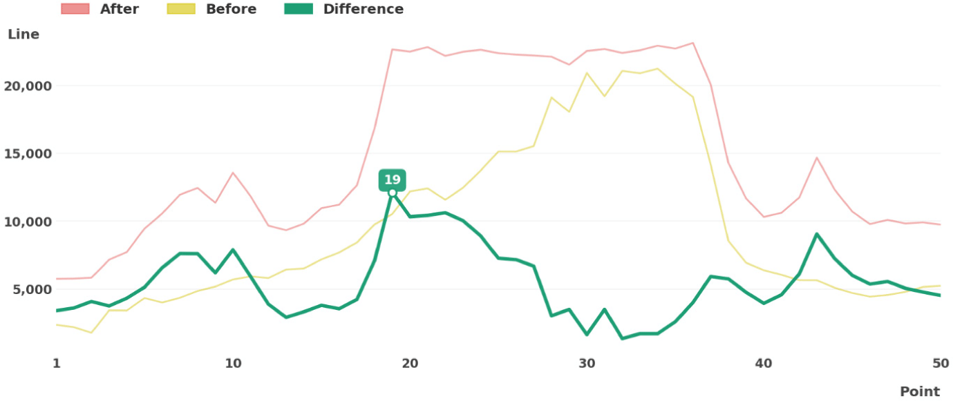
These changes did not occur uniformly across the entire Cheonggyecheon pedestrian axis; rather, a clear spatial concentration was observed in specific sections where the Sewoon District redevelopment building masses directly adjoin Cheonggyecheon. In both indicators, Sky Exposure and Visual Obstruction, the section encompassing observation points 39-56 showed the largest magnitude of change, reflecting that this section falls directly within the sphere of influence of the Sewoon District’s high-rise building masses. In particular, the abrupt increase in building height and the formation of continuous high-rise masses are expected to obstruct pedestrian views simultaneously in the vertical and horizontal directions, thereby directly affecting the spatial openness and psychological comfort perceived by pedestrians beyond mere physical environmental change. As suggested by Asgarzadeh et al. (2012), visual obstruction caused by high-rise buildings acts as a major factor inducing pedestrians’ psychological oppressiveness. The results of this study quantitatively support the possibility that such oppressiveness may be concentrated in the sections adjacent to the Sewoon District. This demonstrates that changes in urban form are not limited to changes in physical indicators, but may also have significant effects on pedestrians’ actual spatial experience and environmental perception.
This study constructed pre- and post-redevelopment scenarios for the Sewoon District and analyzed the impacts of high-rise redevelopment on the public pedestrian environment by comparing Sky Exposure and Visual Obstruction along the Cheonggyecheon pedestrian axis. The results showed that, after redevelopment, some sections experienced a sharp decline in Sky Exposure and an increase in Visual Obstruction, indicating the possibility of a substantial reduction in pedestrians’ perceived Visual Openness. In other words, the continuous placement of high-rise building masses was found to be not merely a change in urban form, but a factor that can alter the openness of the landscape that pedestrians experience sequentially and the spatial experience itself.
Existing discussions on urban redevelopment have largely focused on project-internal quantitative outcomes such as increased development density and floor-area ratio. However, as Carmona emphasizes, urban design is not simply the planning of the physical form of individual buildings, but a process of shaping the quality of the public realm used and experienced by people (Carmona, 2021). From this perspective, changes in urban form caused by redevelopment need to be evaluated not only in terms of the economic logic within individual project sites, but also in terms of external effects on the Visual Openness, landscape continuity, and spatial experience perceived by pedestrians in surrounding public spaces.
By using Sky Exposure and Visual Obstruction as quantitative indicators explaining Visual Openness, this study empirically demonstrated the impact of Sewoon District redevelopment on the pedestrian landscape of Cheonggyecheon as a linear public pedestrian space. This differentiates the study from previous research in that it analyzes changes in urban form before and after redevelopment from the perspective of users of public pedestrian spaces, and it can serve as a basis for landscape management and simulation-based urban design decision-making for urban public spaces such as Cheonggyecheon.
Discussion
This study found simultaneous decreases in Sky Exposure and increases in Visual Obstruction in the Cheonggyecheon section adjacent to the Sewoon District, indicating a decline in pedestrians’ perceived Visual Openness. These results show that, even when building heights are identical, the visual environment of public pedestrian spaces can vary substantially depending on building placement and form.
Current height-management approaches are generally operated around absolute height standards or floor-area ratios, but such approaches alone are insufficient to manage the quality of public landscapes as experienced from the pedestrian viewpoint. In the future, it will be necessary to examine the possibility of introducing minimum visual performance criteria using Sky Exposure and Visual Obstruction so that a certain level of Visual Openness and sequential landscape experience can be maintained after development.
This approach is also linked to discussions on performance-based height management, which move beyond uniform height limits or prescriptive standards and seek to evaluate the effects of development on the urban landscape through three-dimensional simulation in order to determine allowable heights by parcel (Lee et al., 2025). This implies that the appropriateness of high-rise development should be judged not by absolute height alone, but from the perspective of the visual performance of the public pedestrian environment. In particular, the simulation-based analysis method used in this study has the potential to serve as a tool for supporting public decision-making because it enables citizens to intuitively understand landscape changes that may occur after development. In the future, a system is needed that links such quantitative simulation results with urban management planning and citizen participation processes, thereby forming public consensus at the pre-development stage.
Current urban redevelopment projects in South Korea include public hearings and opinion-gathering processes in accordance with statutory procedures; however, the actual participants tend to be limited mainly to landowners and other direct stakeholders. In addition, the main focus of discussions is often concentrated on business feasibility, compensation, and development scale, while civic deliberation on urban publicness or future landscape change remains relatively insufficient. However, because public landscapes such as Cheonggyecheon are not the assets of specific landowners but urban public goods shared by all citizens of Seoul, citizens’ rights to know about and participate in decisions concerning future urban landscape change need to be expanded. In recent years, especially in the fields of urban planning and landscape planning, the use of 3D visualization and digital simulation has been increasingly discussed as an important means of enabling citizens to intuitively understand post-development urban changes and participate in discussions and decision-making about planning alternatives (Lovett et al., 2015).
Vancouver, Canada, drew strong support from local communities through an innovative participation process known as Neighbourhood Visions, which contributed to its reputation as one of the best-planned cities in North America. The case of Vancouver’s open urban design workshops treats citizen participation not merely as opinion collection, but as a core element in the process of shaping future urban landscapes (Punter, 2003).
From this perspective, future development plans around Cheonggyecheon also require a system that moves beyond the review of individual projects and shares scientific simulation results on pre- and post-development landscape changes with citizens, together with the formulation of an urban management plan for the entire Cheonggyecheon corridor. Ultimately, the landscape of Cheonggyecheon is not a by-product of a specific development project but a public asset shared by all citizens of the city, and the process of changing the future urban landscape needs to be discussed in a more open and participatory manner.
Limitations and future research
This study has a limitation in that the study site was selected as an area where the dfference between pre- and post-redevelopment simulation results was clear and predictable; therefore, the findings may remain at the level of numerically confirming expected changes rather than raising new interpretations or contentious issues. Although the study is meaningful in that it analyzed differences in results through quantitative values, it did not examine how those values are related to actual user behavior, satisfaction with the pedestrian landscape, or related factors. In addition, the study did not advance to the stage of proposing how the urban landscape around Cheonggyecheon should be transformed; that is, it did not present concrete urban-form proposals.
In South Korea, the district-unit planning system already provides an institutional basis for systematically managing building placement, form, building lines, public open spaces, pedestrian routes, and ground-floor uses. In practice, however, management centered on floor-area ratio and maximum height tends to take priority, and quantitative management standards for the visual environment and spatial experience perceived from the pedestrian viewpoint remain relatively insufficient. Future research should apply citizen-participatory landscape evaluation methods, such as VR-based experiential assessment and eye-tracking, to diverse urban-form scenarios and measure both positive and negative emotional responses to pedestrian landscapes for each simulation.
In particular, the Visual Openness proposed in this study is a concept that can be quantitatively evaluated through Sky Exposure and Visual Obstruction, and it has the potential to serve as a representative landscape performance indicator for predicting pedestrians’ spatial experience. This would make it possible to verify how quantitative landscape indicators such as Sky Exposure and Visual Obstruction relate to pedestrians’ actual spatial experience, and to identify how relationships among specific urban-form elements, including building height and placement, the placement of public open spaces, building-line setbacks, terraces, and ground-floor openness, affect the improvement of pedestrian landscape quality. Furthermore, if these results are linked with urban management systems such as district-unit planning and developed into landscape management standards and urban design guidelines that can be used at the three-dimensional spatial planning stage, they are expected to contribute to the establishment of a performance-based landscape management system grounded in Visual Openness.