

Introduction
Interest in electric vehicles and autonomous mobility has increased in response to the diffusion of environmental, social, governance (ESG) management, carbon-neutrality policies, and the transition toward environmentally friendly transportation systems. The spread of autonomous driving technology and electric vehicles is expected to induce complex changes in urban spatial structures and in the operational systems of energy infrastructure. If electric vehicle-based autonomous mobility expands, urban energy systems are likely to shift away from existing fossil-fuel-based systems toward electric power networks incorporating energy storage systems (ESS). This transition is closely related to both physical and systemic changes in urban spatial structures.
Previous studies have addressed the development of autonomous driving technology, road operation, parking demand, charging infrastructure, and smart grids. However, most of these studies have been conducted from a vehicle-centered perspective. This study differentiates its research orientation by exploring changes in the spatial distribution and operational systems of urban energy infrastructure from an urban perspective rather than from a vehicle-centered perspective.
The development of autonomous vehicles (AVs) is associated with the potential reorganization of urban space as a whole, including road networks and traffic operation systems. Lee (2016) argued that autonomous driving cannot be fully realized on actual roads through vehicle technology alone and therefore requires a road-cooperation system based on vehicle to everything (V2X), local dynamic map (LDM), and automatied intelligent transport systems (A-ITS). Han et al. (2023) suggested that autonomous driving may affect roads, parking, and travel behavior and emphasized the need for flexible road operations, the conversion of parking spaces, and public transport-centered integrated planning. Litman (2025) observed that the commercialization of AVs is likely to unfold over the long term depending on technology, cost, regulation, and safety verification; accordingly, the urban impacts of autonomous driving should also be examined in stages. Research on electric vehicle charging infrastructure and power-grid integration constitutes another axis of the discussion on autonomous driving-based urban energy infrastructure. The International Energy Agency (IEA, 2022) noted that the expansion of electric vehicles may affect the power grid, but that smart charging, demand response, and time-of-use charging management can alleviate electricity loads and enable electric vehicles to function as flexibility resources within the power system. Kiasari et al. (2024) described the smart grid as a core infrastructure that integrates renewable energy, bidirectional flows of power and data, ESS, and communication and control systems. These studies suggest that electric vehicle charging facilities can operate as components of an urban energy network linked to distribution networks, ESS, vehicle to grid, vehicle-to-building (V2G/V2B), and charging management systems.
Domestic and international autonomous driving pilot districts also demonstrate the potential transformation of urban space. The Daejeon-Sejong cooperative intelligent transport systems (C-ITS) pilot project, the Sangam 5G autonomous driving pilot district in Seoul, and the Pangyo AV pilot operation district have tested autonomous driving environments centered on V2X, integrated control, high-definition (HD) maps, and pedestrian-vehicle information exchange (Ministry of Land, Infrastructure and Transport, 2014, 2019, 2021). International examples, including Waymo’s service-area-based robotaxi service (Waymo, 2023), Singapore’s One-north testbed (Land Transport Authority, 2017), and Hamburg’s ITS-C-based test zone (Behörde für Verkehr und Mobilitätswende, n.d.), demonstrate the importance of road operation and data-based control systems. The wireless charging road case in Detroit can be interpreted as an example showing that the road itself may be transformed into linear energy infrastructure (City of Detroit, 2023). However, existing studies and cases tend to address autonomous driving technology, road operation, parking demand, charging infrastructure, and smart grids separately. Therefore, based on previous studies and case investigations, this study derives factors of change in urban energy infrastructure according to the development stages of autonomous driving and structures them into a staged transformation pathway through scenario analysis.
Methods
A scenario-based methodology was applied to analyze potential changes in urban energy infrastructure. Rather than predicting the future as a single predetermined outcome, scenario methods construct multiple possible futures by combining key drivers of change and examining their potential trajectories (Godet, 2000). For research topics characterized by substantial uncertainty in the pace of technological development and the ways in which such technologies are spatially adopted in urban environments, such as technology stages, road networks, and energy networks, scenario methods are appropriate for structurally analyzing long-term directions of change.
The scenario method was adopted in this study for the following reasons. First, the timing of commercialization and the rate of diffusion of AVs may vary depending on technology, institutions, and market acceptance, making them difficult to explain through a single future projection. Second, urban energy infrastructure involves diverse elements—charging facilities, distribution networks, smart grids, ESS, and V2X-based operation systems—that are interconnected with road networks and transportation systems; therefore, it should be interpreted as a staged and complex transformation rather than as a linear change. Third, the purpose of this study is not to quantitatively forecast demand in a specific city but to exploratorily derive the directions in which the spatial distribution and operational systems of energy infrastructure may be reorganized as autonomous driving develops.
The analytical procedure was organized as follows. First, variables were derived from previous studies and domestic and international autonomous driving demonstration cases, and scenario modules were developed by constructing a matrix among the variables. Next, each scenario was assessed according to defined criteria to determine whether it had logical suitability among the variables. A strength, weakness, opportunity, threat (SWOT) analysis was then conducted for the suitable scenario modules to examine the strengths, weaknesses, opportunities, and threats of each combination (Weihrich, 1982). Subsequently, the scenarios with confirmed suitability were arranged according to their possible temporal development to derive a staged development pathway. The scenarios in this study should be understood not as deterministic future predictions but as qualitative analytical results that structure the direction of spatial reorganization of energy infrastructure for future urban planning and design.
To construct scenarios according to the methodology, three variables—technology stage, road network, and energy network—were established based on previous studies and domestic and international case investigations. These variables were derived as key axes for explaining the level of autonomous driving technology, the physical basis through which autonomous driving is integrated into actual urban space, and the energy supply system that changes with the spread of electricity-based mobility.
The technology stage is a reference variable that determines the operational range of AVs and the required level of urban infrastructure. According to SAE International (2021), autonomous driving technology is classified into stages according to the degree of driver intervention and the conditions under which operation is possible. Among Levels 1–5, Level 4, in which autonomous driving is possible under limited conditions, and Level 5, in which full autonomous driving is possible under most conditions, were selected as the analytical scope.
The road network is a physical variable that determines urban form and patterns of spatial use. Lee (2016) argued that the stable operation of AVs requires an A-ITS-based road-cooperation system that incorporates vehicle technology, V2X, LDM, and real-time monitoring. Han et al. (2023) also suggested that the spread of autonomous driving may affect road operation, parking spaces, travel behavior, and urban spatial structures, thereby necessitating flexible road operations and integrated transportation planning. Cases such as the Daejeon-Sejong C-ITS project, the Sangam 5G autonomous driving pilot district in Seoul, Singapore’s One-north, and Hamburg’s ITS-C demonstrate that AV operation is integrated with road infrastructure such as V2X equipment, roadside sensors, HD maps, integrated control, and intersection operation. Accordingly, the road network is the physical and operational foundation through which autonomous driving technology actually functions within urban space and should be established as a variable explaining changes in urban infrastructure across the development stages of autonomous driving. The road-network variable was defined according to three principal conditions: maintaining current conditions, operational change (V2X), and spatial reorganization.
The energy network is a variable directly associated with the spread of electric vehicle-based autonomous mobility. The IEA (2022) noted that the expansion of electric vehicles may affect power grids, while smart charging, demand response, and time-of-use charging management can regulate electricity loads and allow electric vehicles to serve as flexible energy resources. Kiasari et al. (2024) explained that the smart grid is a core infrastructure that integrates renewable energy, bidirectional flows of power and data, energy storage devices, and communication and control systems. The Detroit case also demonstrates that roads may be transformed into linear energy infrastructure with power-supply functions. These discussions and cases suggest that energy infrastructure may be reorganized into an urban-scale energy network combined with distribution networks, smart grids, ESS, V2G/V2B, and charging management systems. Therefore, the energy network was established as a variable for explaining charging demand, electricity loads, energy supply modes, and integrated transportation-energy operation according to the development of autonomous driving. The energy-network variable was defined according to three principal conditions: maintaining current conditions, mixed transition, and charging-centered operation.
To determine the logical suitability of the scenario modules developed from the three variables, six suitability evaluation criteria were established based on previous studies and case investigations. These criteria consist of technology-stage suitability, road-network transition suitability, energy-network suitability, transportation-energy connectivity, spatial implementation feasibility, and transition-risk manageability. Through these criteria, modules in which the road network or energy network excessively preceded or lagged behind the technological level, or in which functional linkages among variables were insufficient, were excluded. The basis for establishing each evaluation criterion is presented in the following Table 1.
| No. | Suitability evaluation criterion | Basis for criterion |
|---|---|---|
| 1 | Technology-stage suitability | SAE J3016 classifies autonomous driving into levels, each differing in the degree of driver intervention and operating conditions; therefore, it is necessary to evaluate whether the road-network and energy-network levels of a given scenario correspond to the relevant technology stage (SAE International, 2021). |
| 2 | Road-network transition suitability | Because autonomous driving operates in conjunction with road infrastructure such as V2X, LDM, real-time monitoring, signal control, and integrated control, it is necessary to evaluate whether the level of road-network transition corresponds to the autonomous driving stage (Han et al., 2023; Lee, 2016; Daejeon-Sejong C-ITS and related pilot cases). |
| 3 | Energy-network suitability | As the expansion of electric vehicles is associated with charging demand, distribution-network loads, smart charging, ESS, and V2G/V2B, it is necessary to evaluate whether the energy-network level can support charging and electricity demand (IEA, 2022; Kiasari et al., 2024). |
| 4 | Transportation-energy connectivity | Considering the potential interconnection among autonomous vehicle routes, waiting locations, charging demand, and electricity loads, it is necessary to evaluate the level of integrated management between traffic-operation information and energy demand (IEA, 2022; Kiasari et al., 2024). |
| 5 | Spatial implementation feasibility | From an urban perspective, it is necessary to evaluate whether charging facilities, road sections, major transportation nodes, and road-integrated infrastructure can be technically applied at the temporal and technological stage assumed in each scenario (Han et al., 2023; Sangam, Pangyo, and Detroit cases). |
| 6 | Transition-risk manageability | Through a SWOT analysis of scenarios for autonomous driving and future energy infrastructure, it is necessary to evaluate transition risks related to uncertainties in technology, cost, institutions, and safety verification (Godet, 2000; Litman, 2025; Weihrich, 1982). |
Each criterion was evaluated using a five-point Likert scale ranging from 1 (very low suitability) to 5 (very high suitability). The total score was calculated out of 30 points. A scenario was classified as suitable when its score was 22 points or higher, corresponding to 70% of the maximum score, and when the suitability scores for the technology stage, road network, and energy network were all 3 or higher. Conversely, when the total score was below 22 or when any of the three core variables scored 2 or lower, the scenario was classified as unsuitable because the transition level among variables was considered unbalanced or its applicability within urban space was judged to be low.
The derived scenario modules were assigned symbols to improve the visual clarity of combinations among variables. The technology stages were denoted as [(1), (2)], the road network as [A, B, C], and the energy network as [a, b, c], as summarized in the following Table 2.
The logical suitability of each scenario module was assessed using the following Table 3. In addition, for the suitable scenarios only, a SWOT analysis was conducted and presented to identify the strengths, weaknesses, opportunities, and threats of each scenario (Table 4).
Among the 18 derived scenario modules, the optimal scenario was identified by analyzing the staged development pathway based on the realistic possibility of each scenario’s unfolding and the logical suitability among its components. The development pathway among suitable scenario modules for deriving the optimal scenario was established according to three principles. First, under the assumption that each variable changes in stages, only one variable was allowed to change at a time. Second, cases in which the development process reverted to a previous stage were excluded because they were judged inconsistent with realistic transition processes. Third, physical changes such as the spatial reorganization of the road network were assumed to occur in the final stage because of their irreversible characteristics. Based on these criteria, the transition possibilities and development pathways among scenarios were systematically organized, and each derived scenario module was named P1, P2, and so forth, using the abbreviation for Phase according to its temporal stage. The transition-possibility review identified the following optimal scenario as the most realistic and logically suitable staged pathway (Table 5).
The derived optimal scenario is presented as a development pathway formed through staged changes in each variable and their mutual linkages. It can be interpreted as indicating a realistic direction for the structural transition of autonomous driving-based urban energy infrastructure.
Results
This section analyzes the spatial transformation of urban energy infrastructure according to the development stages of autonomous driving, focusing on P1–P6, which were identified as logically suitable among the 18 scenario modules derived above.
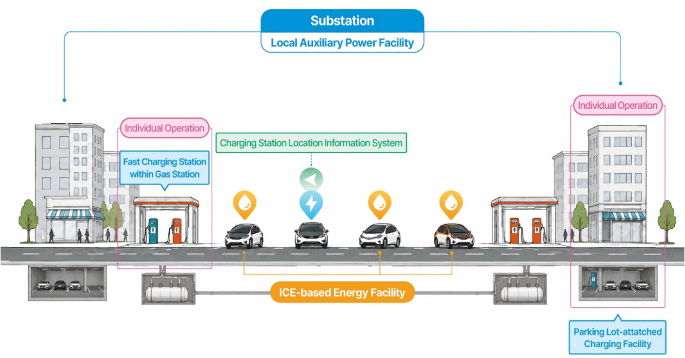
P1 represents the initial entry into Level 4 autonomous driving, in which technological advances occur experimentally while the existing urban structure is maintained. The road network continues to operate primarily for internal combustion engine (ICE) vehicles, while dedicated AV lanes and intersection control systems are applied only in limited pilot sections. The energy network also retains a gasoline-station-centered structure based on ICEs, and electric vehicle charging facilities are installed only in public facilities and some parking lots. Vehicle use and the parking system also remain centered on private ownership and fixed parking spaces. P1 corresponds to the current level and functions as a baseline for comparing energy transition and spatial reorganization (Fig. 1).
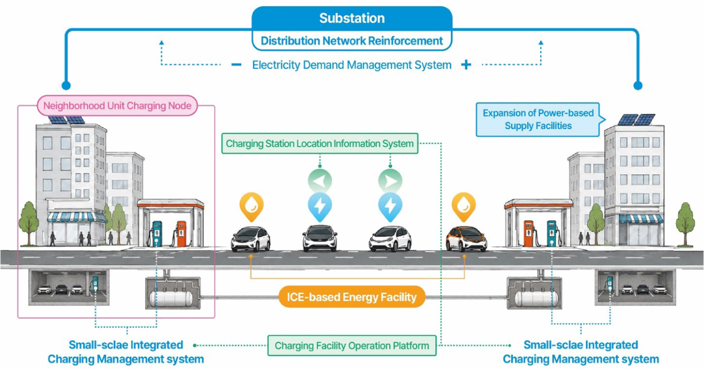
P2 is a stage within the Level 4 autonomous-driving transition process in which the energy network develops in advance and undergoes quantitative expansion. Although an energy system centered on ICEs remains dominant, rapid and slow charging facilities expand around public parking lots, large commercial facilities, and apartment complexes as the diffusion rate of electric vehicles gradually increases. As a result, existing gasoline stations and power-based supply systems coexist. In some areas, distribution networks are reinforced in response to growing charging demand. During this process, data on the locations of charging facilities, usage patterns, and electricity demand accumulate, helping to specify the future direction and operational methods of energy-network expansion. P2 can be interpreted as a transitional stage that verifies the possibility of energy-network transformation and prepares for subsequent functional coordination with the road network (Fig. 2).
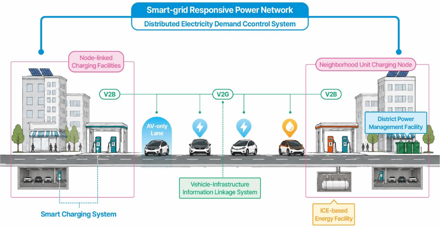
P3 is the stage in which information linkages with the road network begin in response to changes in the energy network. A V2X-based traffic operation system is introduced into the road network, enabling real-time information exchange between vehicles and infrastructure. Traffic signal control, intersection operation, and traffic-flow management are advanced, and dedicated AV lanes are applied. The energy network maintains a mixed structure in which existing gasoline stations and charging infrastructure coexist because ICE vehicles remain in use. However, networks are formed among the charging facilities that expanded quantitatively in earlier stages, and vehicle movement and demand information collected through V2X are used for the siting and operation of charging facilities. As a result, interactions between the transportation system and the energy network begin to emerge. P3 can be regarded as a period in which the linkage between road-network operational change and energy transition begins to be secured, enabling stable AV operation (Fig. 3).
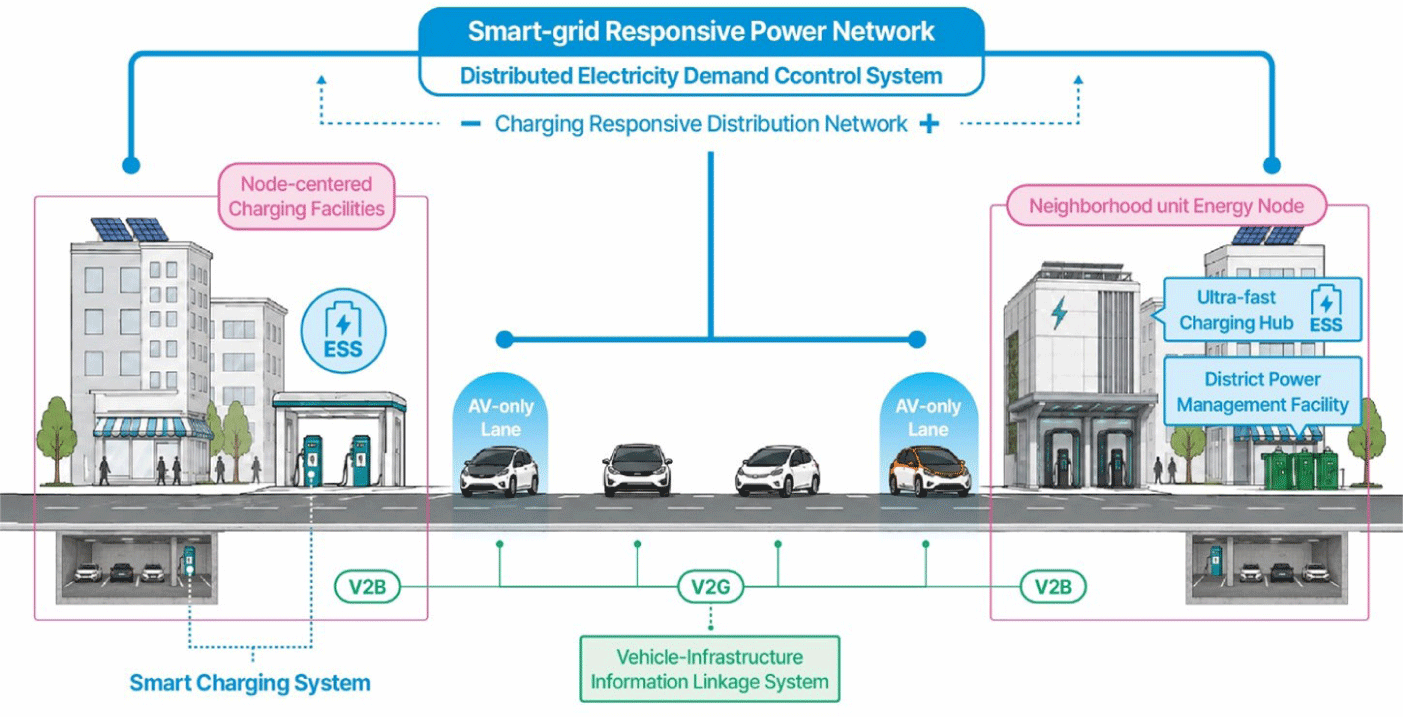
P4 is the stage in which the V2X-based road operation system is advanced and, as the diffusion rate of electric vehicles increases, the energy network shifts toward a charging-centered system. Although the physical structure of the road is maintained, traffic flow and AV operation are stably managed through real-time information exchange between vehicles and infrastructure. In addition, as the proportion of electric vehicles becomes overwhelmingly higher than that of ICE vehicles, rapid and slow charging facilities are expanded on a large scale in urban centers and major transportation nodes, forming a dense energy network. Existing gasoline stations are gradually converted into complex charging stations and ESS facilities. Distribution networks and substations are reorganized to respond to increasing electricity demand, while some districts or buildings introduce distributed power sources and ESS that independently produce, store, and consume electricity. In addition, the siting and operation of charging facilities can be optimized by linking vehicle movement and dwell-time data with electricity demand, while smart charging can distribute loads by time period. P4 is interpreted as a stage in which the linkage between traffic operation and energy management is strengthened and a stable electricity-centered energy system is formed (Fig. 4).
P5 is the systemic completion stage in which V2X-based road operation systems and charging-centered energy networks operate in an integrated manner as autonomous driving technology reaches Level 5. At this stage, most vehicles are converted into electric vehicles capable of autonomous driving. Through real-time information exchange between vehicles and infrastructure, traffic flow, intersections, and unexpected events are managed in an integrated manner, and the operational efficiency and safety of fully AVs are secured at the urban scale. Charging infrastructure, distribution facilities, and substations are also expanded throughout the city, and energy management linked to traffic demand is implemented through smart grids and distributed energy systems. Accordingly, traffic flow, charging demand, and electricity loads are interconnected in real time, enabling the spatiotemporal distribution of charging demand and efficient load management. This integrated structure maximizes the efficiency of urban-scale resource operation through systemic optimization between transportation and energy. Although this stage may be characterized by a stable system structure in which suitability among components is secured, it centers on the advancement of V2X-based operations; therefore, it can be regarded as a stage in which the integrated transportation-energy operation system is stabilized and advanced at the urban scale (Fig. 5).
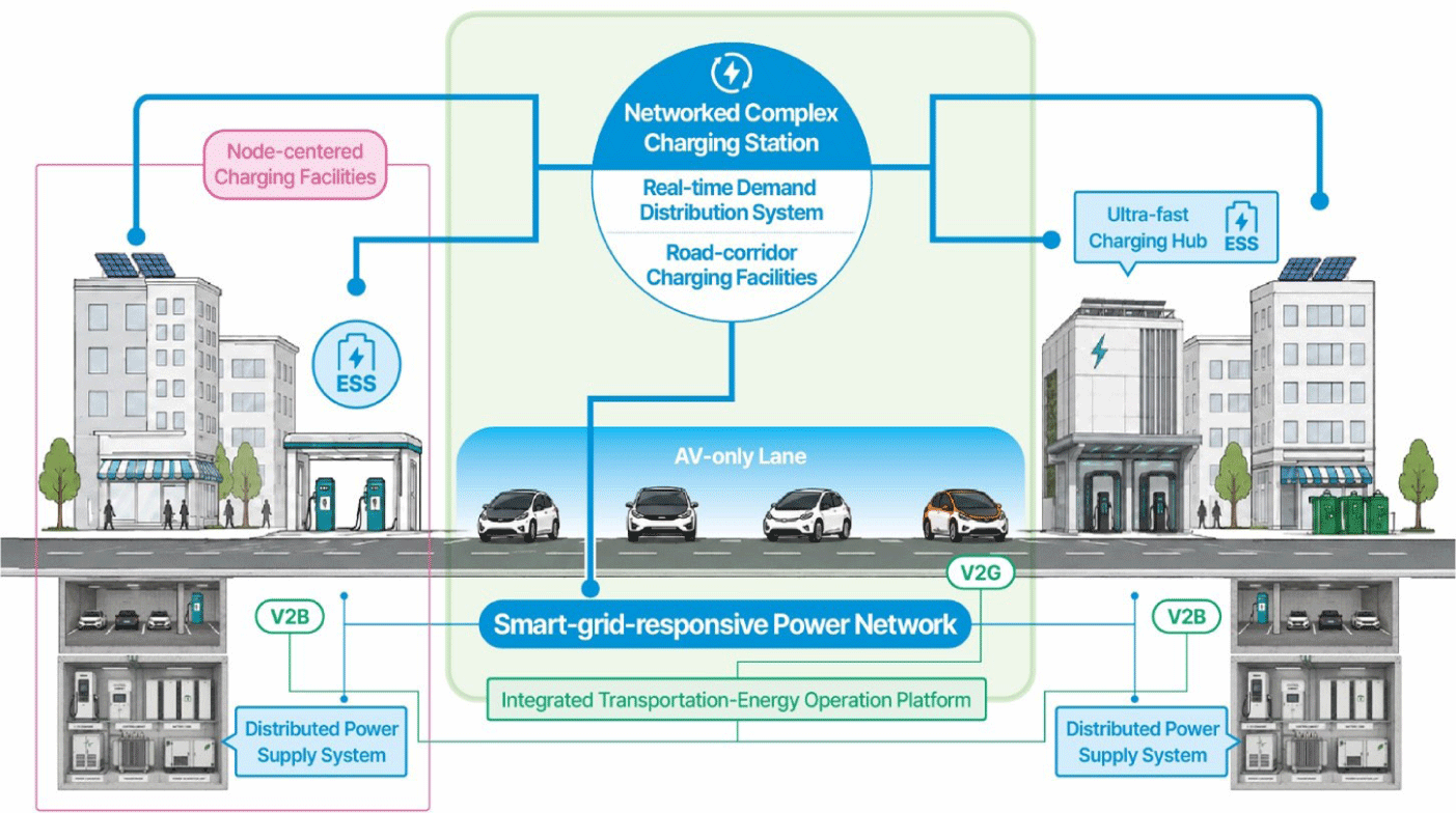
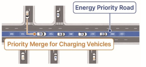
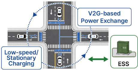
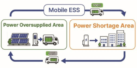
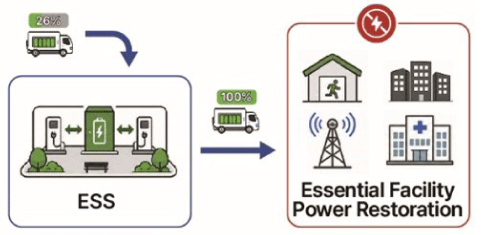
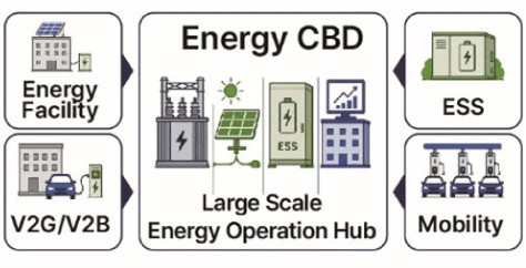
P6 is the stage in which the road network is reorganized based on a stabilized integrated transportation-energy system. Road space is physically transformed through lane reconfiguration, the provision of dedicated autonomous driving spaces, and the reduction and redesign of intersections, while the overall urban space is reorganized to correspond to the autonomous transportation system. Charging infrastructure is constructed at high density across the city, and a power-based transportation system is stably supported through the reinforcement and undergrounding of distribution networks and substation facilities, as well as the introduction of smart grids and distributed energy systems. In the road network, various road-based spatial applications dedicated to autonomous driving are introduced, including energy-priority roads, power-exchange intersections, and mobile ESS circulation loops, along with road-integrated charging infrastructure and complex energy hubs at major transportation nodes. Accordingly, traffic flow and energy demand are linked in real time, and the distribution of charging demand and the regulation of electricity loads are advanced. P6 is evaluated as a stage of physical transformation in which autonomous driving technology, the road network, and the energy network are spatially and operationally integrated to optimize mobility and energy efficiency (Fig. 6).
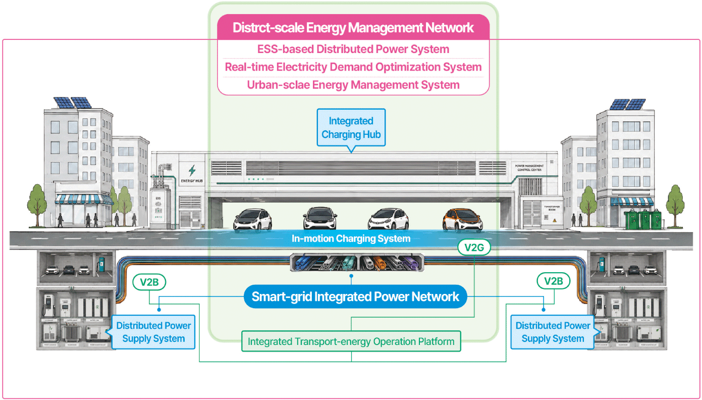
Upon entering P6, the functions and spatial scope of energy infrastructure expand to roads and major transportation nodes. Roads perform functions related to power supply, storage, exchange, and data linkage, while AVs can be used not only as means of mobility that consume energy but also as distributed energy resources that store, transport, and supply electricity. Based on these technological and spatial conditions and on the spatial transformation patterns of energy infrastructure identified in P1–P6, this study proposes energy-priority roads, power-exchange intersections, mobile ESS circulation loops, power-recovery pockets, and an energy CBD as new types of energy infrastructure. These are conceptual infrastructure typologies that concretize the potential spatial and operational integration of future autonomous transportation systems with urban energy networks (Table 6).
Discussion
The optimal P1–P6 scenario derived in this study illustrates a spatial transformation process in which urban energy infrastructure shifts from a supply system centered on individual facilities to an integrated urban-scale network as autonomous driving develops. In the early stages, P1–P2, existing substation-based centralized power supply facilities and individual building-level charging facilities are the main elements. In P3–P4, distribution networks are reinforced, smart-grid-responsive power networks and V2X-based charging operation systems are introduced, and linkages are formed between traffic operation information and charging demand. In P5–P6, integrated transportation and energy operation platforms and distributed power systems are established, while roads and major transportation nodes are transformed into complex infrastructure that performs power supply, storage, and exchange functions. Accordingly, conceptual infrastructure such as energy-priority roads, power-exchange intersections, mobile ESS circulation loops, power-recovery pockets, and an Energy CBD can be formed. In summary, the transformation of energy infrastructure associated with the development of autonomous driving can be interpreted as an urban-scale structural change in which road networks, transportation nodes, and power grids are spatially and operationally integrated.
The results of this study indicate that, in future autonomous driving-based urban planning, transportation planning and energy planning will be difficult to treat as separate spatial domains. When the movement routes, waiting locations, charging demand, and electricity loads of AVs are mutually interconnected, energy infrastructure can function as a planning element that underpins urban planning together with the road network. Accordingly, energy infrastructure needs to be reinterpreted not as equipment attached to individual buildings or parking lots but as a key infrastructure element in urban design connected to neighborhood units, road corridors, and major transportation nodes.
From an urban design perspective, energy infrastructure should be examined as core infrastructure constituting neighborhood units and major transportation nodes, with a focus on improving everyday convenience and energy efficiency. In the initial stage, charging facilities are mainly inserted into existing urban spaces such as apartment complexes, commercial and office facilities, and public parking lots. However, as autonomous driving technology and energy networks become more advanced, energy infrastructure develops into neighborhood energy nodes, charging facilities centered on major transportation nodes, urban-scale networked charging nodes, and integrated complex charging hubs. This implies that major transportation nodes need to be redefined as complex urban energy infrastructure that not only improves transfer and mobility convenience but also performs charging, waiting, logistics, ESS, and information-linkage functions.
Road space is also transformed from linear infrastructure for movement into complex infrastructure in which transportation, energy, and information functions overlap. In P3–P4, road-linked charging facilities and V2X-based charging operation systems emerge, and in P6, in-motion charging systems and road-integrated charging infrastructure are proposed. This means that future road-network planning should comprehensively consider lane composition, road cross-sections, underground utility infrastructure in common ducts, power-supply facilities, and data-linkage devices as part of spatial utilization strategies. Therefore, in cities based on fully autonomous driving, integrated infrastructure and spatial planning are required to examine traffic flow, charging demand, electricity loads, and information linkages together.
This study is significant in that it analyzes the spatial transformation of urban energy infrastructure according to the development stages of AVs through a scenario-based approach. However, it has limitations in terms of quantitative verification using an actual city. The changes in power and charging demand, infrastructure scale, and infrastructure location presented in each scenario are spatial interpretations of possible future changes and were not expanded into an empirical analysis that reflects the traffic volume, electricity load, land use, and population density of a specific city. Therefore, the results of this study should be understood not as design standards derived from a comprehensive review of multiple factors but as an analytical framework for anticipating the direction of the physical and spatial reorganization of energy infrastructure according to the development of autonomous driving.
In addition, this study derived suitable scenarios centered on technology stage, road network, and energy network. However, actual urban change may be affected by various external factors, including policies and institutions, market acceptance, economic conditions, battery technology, charging standards, and investment methods. In particular, because the timing of commercialization and the diffusion rate of autonomous driving technology involve substantial temporal uncertainty, this study is limited in that it does not assign a specific timeframe to the scenario development pathway it proposes.
Future research should apply the scenario pathway developed in this study to a specific city or neighborhood unit and quantitatively examine electricity demand, the spatial distribution of charging demand, and the locational suitability of major transportation nodes. In addition, if the relationship between AV operation patterns and energy infrastructure is empirically analyzed using geographic information analysis (GIS)-based spatial analysis, traffic simulation, and electricity-load prediction models, the results could be extended into more specific design strategies for future urban design and urban planning.

